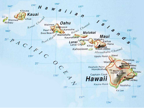
When you picture a map of Hawaii, you likely envision the eight major islands: a familiar cluster in the vast Pacific Ocean. But this popular image represents only a fraction of the whole story. The true Hawaiian archipelago is a colossal chain of 137 islands, atolls, reefs, and seamounts stretching over 1,500 miles. This guide explores the complete map of Hawaii, revealing the hidden Northwestern Hawaiian Islands and the powerful geological forces that created this incredible island chain.
Beyond the Postcards: The 8 Main Hawaiian Islands
The eight main islands, also known as the Southeastern or Windward Islands, are the cultural, economic, and population centers of Hawaii. They are the youngest and largest islands in the chain, formed by ongoing volcanic activity. From east to west, they are:
- Hawaiʻi (The Big Island): The largest and youngest island, home to active volcanoes like Kīlauea and Mauna Loa.
- Maui (The Valley Isle): Known for its stunning beaches, the dormant Haleakalā volcano, and the scenic Road to Hāna.
- Kahoʻolawe (The Target Isle): The smallest of the main islands, it is uninhabited and holds deep cultural significance. Access is restricted.
- Lānaʻi (The Pineapple Isle): Once a massive pineapple plantation, it is now a destination for luxury and seclusion.
- Molokaʻi (The Friendly Isle): Retains a strong connection to its traditional Hawaiian roots and features the world’s highest sea cliffs.
- Oʻahu (The Gathering Place): The most populous island, home to the state capital, Honolulu, and the historic Pearl Harbor.
- Kauaʻi (The Garden Isle): Famed for its dramatic cliffs, lush rainforests, and the breathtaking Nāpali Coast.
- Niʻihau (The Forbidden Isle): A privately owned island with a predominantly Native Hawaiian population, where traditional culture and language are preserved.
Unveiling the True Map: The Northwestern Hawaiian Islands (NWHI)
Stretching northwest from the main islands is a remote and ecologically vital chain of small islands, atolls, and reefs known as the Northwestern Hawaiian Islands. This region, collectively named Papahānaumokuākea Marine National Monument, is one of the largest marine conservation areas in the world and a UNESCO World Heritage site.
What is Papahānaumokuākea?
The name Papahānaumokuākea commemorates the union of two Hawaiian ancestors: Papahānaumoku (the earth mother) and Wākea (the sky father). This name reflects the deep cultural belief that this region is the root of ancestral knowledge and the place where life originates and returns after death. These islands are largely uninhabited by humans and are a critical sanctuary for wildlife.
A Chain of Atolls, Reefs, and Seamounts
Unlike the high, volcanic main islands, the NWHI are much older, smaller, and lower in elevation. They represent the later stages of an island’s life cycle, where volcanic mountains have eroded and subsided beneath the ocean’s surface, leaving behind coral reefs and atolls. Key islands in this protected chain include Nihoa, Mokumanamana, French Frigate Shoals, and Kure Atoll—the oldest and most remote coral atoll in the entire archipelago.
The Science Behind the Chain: Volcanic Hotspot Theory Explained
The long, linear arrangement of the Hawaiian Islands is not a coincidence. It is the direct result of the Pacific Plate moving over a stationary “hotspot” of magma deep within the Earth’s mantle. This geological process is the engine that has built the entire 1,500-mile archipelago over tens of millions of years.
How the Hawaiian Hotspot Works
Imagine a fixed candle (the hotspot) and a piece of paper (the Pacific Plate) slowly sliding over it. As the paper moves, the candle flame burns a series of marks in a straight line. Similarly, the Hawaiian hotspot remains in one place, punching through the Pacific Plate as it drifts northwestward. This process creates new volcanoes that eventually rise above the sea to form islands. The Big Island is currently positioned directly over the hotspot, which is why it is the only island with active volcanism.
The Island Life Cycle: From Volcano to Atoll
As the Pacific Plate carries the newly formed islands away from the hotspot, their volcanic activity ceases. Over millions of years, they undergo a predictable life cycle:
- Active Volcano: The island is young, growing, and directly over the hotspot (e.g., Hawaiʻi Island).
- Erosion Stage: The island moves off the hotspot, and wind and rain begin to erode the volcanic shield (e.g., Oʻahu and Kauaʻi).
- Subsidence & Reef Growth: The island’s crust cools and becomes denser, causing it to slowly sink. Coral reefs grow around the sinking shoreline.
- Atoll Stage: The central volcanic island completely subsides beneath the water, leaving a ring-shaped coral reef and a shallow lagoon (e.g., Kure Atoll).
- Seamount Stage: Eventually, the atoll also sinks below the ocean surface, becoming a submerged mountain known as a seamount or guyot.
Main Islands vs. Northwestern Islands: A Comparison
The contrast between the two sections of the Hawaiian archipelago is stark. The main islands are hubs of human activity and tourism, while the NWHI are a protected wilderness dedicated to conservation and cultural preservation.
| Feature | Main Hawaiian Islands (Southeastern) | Northwestern Hawaiian Islands (NWHI) |
|---|---|---|
| Geology | Young, high, active, or dormant volcanic islands. | Old, low-lying atolls, reefs, and eroded volcanic remnants. |
| Population | Home to over 1.4 million residents and millions of tourists. | Virtually uninhabited; access is strictly limited to researchers and cultural practitioners. |
| Conservation Status | Mixed-use with national parks, cities, and agriculture. | Protected as Papahānaumokuākea Marine National Monument. |
| Primary Role | Economic, cultural, and residential center of the state. | Ecological sanctuary and a site of profound cultural significance. |
Expert Advice: Appreciating Hawaii’s Full Geography
While visiting the NWHI is not possible for the general public, you can still deepen your appreciation for Hawaii’s complete geography.
- Visit Educational Centers: The Mokupāpapa Discovery Center in Hilo, Hawaiʻi, offers exhibits and information about the Papahānaumokuākea monument.
- Explore Digital Maps: Use tools like Google Earth to virtually fly along the entire 1,500-mile chain. You can clearly see the progression from high islands to low atolls.
- Watch Documentaries: Seek out films that explore the unique ecosystems and conservation efforts in the NWHI to understand what makes this region so special.
- Support Conservation: Learn about and support organizations dedicated to protecting Hawaii’s fragile marine and terrestrial environments.
Frequently Asked Questions (FAQ)
- How many islands are really in Hawaii?
- The state of Hawaii is comprised of 137 islands, islets, and atolls that form the Hawaiian archipelago. This includes the eight well-known main islands and the 129 largely uninhabited Northwestern Hawaiian Islands.
- Can you visit the Northwestern Hawaiian Islands?
- No, public access and tourism are prohibited in the NWHI to protect their fragile ecosystems and cultural sites. Access is strictly limited to those with specific permits for scientific research, conservation, or cultural purposes.
- Why are the Hawaiian islands in a straight line?
- The islands form a linear chain because the massive Pacific tectonic plate is moving in a northwesterly direction over a stationary volcanic hotspot in the Earth’s mantle. This movement creates a trail of islands, with the oldest in the northwest and the youngest in the southeast.
- Is the Hawaiian island chain still growing?
- Yes. The Hawaiian hotspot is still active. Southeast of the Big Island, a new submarine volcano named Lōʻihi is currently erupting deep underwater. It is expected to breach the ocean’s surface and become a new Hawaiian island, but this will likely take tens of thousands of years.
